The staircase down from the street had previously been walled off, but now the wall and the fence on top of it had been altered to reopen the stairs onto the sidewalk. The path that wraps around under the railroad tracks to the train station has been cleared and repaved. The vines that had covered the carved stone on the wall have been cleared off. A new fence closes off the train tracks, replacing the ruins of the old iron fence that had been broken and partially consumed by decades of tree growth. Construction debris that had previously been dumped in this area was gone and the place looks remarkably clean. We saw a couple people stroll or jog through enjoying the path and stairs while we were there.
Showing posts with label parks. Show all posts
Showing posts with label parks. Show all posts
Saturday, December 5, 2020
The Path of Restoration
Abandoned places in New York City are becoming increasingly rare. On a recent excursion with my son, I intended to go explore an abandoned place I hadn't visited for a few years. When we got there, I discovered that it had been reactivated.

Monday, May 4, 2020
Not-So-Safe Streets
During the current global pandemic, there has been a precipitous drop in driving. Traffic has all but evaporated on New York City's streets. Meanwhile, sidewalks and parks are not providing enough space for people to walk for essential trips, including some basic exercise. Repurposing the residual street space for walking is an obvious solution, and one that is increasingly pursued in cities around the world. New York has been slow to follow, with the Mayor resisting the very idea until continuing to refuse to open streets became politically untenable. Under order of the Governor to do something, he initially opened a few random streets and posted lots of police officers on every block. Shortly thereafter, he pulled it, claiming the police costs were too high.
Public and political pressure continued to mount, expecially as examples continued to come in from other cities. Photo after photo of from other cities closing streets with simple barriers without a heavy police presence made it untenable to continue insisting that New York City was so unique that we could not open our streets too. Finally, another small number of short street segments were announced for an initial opening this past weekend.
Public and political pressure continued to mount, expecially as examples continued to come in from other cities. Photo after photo of from other cities closing streets with simple barriers without a heavy police presence made it untenable to continue insisting that New York City was so unique that we could not open our streets too. Finally, another small number of short street segments were announced for an initial opening this past weekend.
The first day at the Oval only had a small hiccup. The barriers were placed at Reservoir Oval itself, stopping traffic after it had turned onto the inlet streets, with no good way to turn back around. When the street openings were announced with their mileages, I wondered why DOT had not taken credit for the additional mileage from those side streets. The day before the street opened, my 8-year-old son was even thinking out loud on his own about where the barriers would need to be placed for these streets. Just a couple hours after the Safe Street opening, the NYPD recognized and corrected the situation by bringing out additional barriers to intercept the drivers before turning onto those streets. Still, it was an inexplicable mistake for professionals to make.The charitable way to greet this is that ... it's only a start. They risk making destinations of these streets with slow ramp-ups, though. You can have my street! pic.twitter.com/HQ03v3p4sJ— Nicole Alone of Silent West Midtown 🌸🐿💐🌺🌹☔️🐥 (@nicolegelinas) May 1, 2020
The Oval seems to be working well as an open street today. pic.twitter.com/PjPjd1vc54— Urban Residue (@urbanresidue) May 2, 2020
Monday, November 12, 2018
Two Sides of the Same Woods
On one side of the road, you have tourists reading plaques about trees. On the other, gay men circle the woods looking for potential hookups. The Bronx River Forest is one of the few remaining sections of the great woodland that once covered the New York region. While we tend to consider the plants and animals that populate wooded areas like this as "wild," this landscape is highly shaped by the physical interventions and social activities of humans. It is easy to overlook how much human action can shape the "natural" environment, but the differences created by separate jurisdictional control over trails winding through the woods along the Bronx River on each side of Allerton Avenue create a stark contrast.
South of Allerton Avenue, the Bronx River flows through the New York Botanical Garden. Since the 1890s, this land has been City parkland, part of Bronx Park, which is administered by a private institution specifically charged with the development and maintenance of a great living museum. To the north, the parkland is under conventional control of the New York City Department of Parks and Recreation.
There are some physical differences in terrain between the two sections. To the north, the river passes through a floodplain. After flowing into the garden, it quickly drops into a ravine with some moderately steep slopes down to the river. Nonetheless, the main distinctions between these two sections is how the land is managed and access is controlled.
 |
People duck under a fallen tree (covered in poison ivy) on the Blue Trail north of 204th Street in the Bronx Forest managed by the Department of Parks and Recreation
|
 |
Tourists stop along the trail in the Thain Family Forest in the New York Botanical Garden to read facts about the trees
|
South of Allerton Avenue, the Bronx River flows through the New York Botanical Garden. Since the 1890s, this land has been City parkland, part of Bronx Park, which is administered by a private institution specifically charged with the development and maintenance of a great living museum. To the north, the parkland is under conventional control of the New York City Department of Parks and Recreation.
There are some physical differences in terrain between the two sections. To the north, the river passes through a floodplain. After flowing into the garden, it quickly drops into a ravine with some moderately steep slopes down to the river. Nonetheless, the main distinctions between these two sections is how the land is managed and access is controlled.
Sunday, February 18, 2018
Staring at the Pole
I was recently at Frederick Douglass Circle at the northwest corner of Central Park. Every time I go, I am bothered by a detail that detracts from the relationship between the plaza and its surroundings. I am not sure if the detail was on the drawings I first say many years ago, but if it was I certainly missed it.
Back in 2003, I attended a public meeting for neighbors skeptical about the transformation of Frederick Douglass Circle into a public space. At the conclusion of years of participatory planning and a design competition, residents of Towers on the Park emerged with last-minute objections to various aspects of the reconfiguration of the previously dysfunctional intersection (the circle was previously cut through by traffic, creating far too many movements as well as lane drops in the middle of the intersection...). I spoke in favor of the project, convinced it would create a great new public space.
Then construction stretched on for many years. It was disruptive for everybody in the area and continued long beyond what any resident would consider reasonable. I second guessed myself for speaking up after seeing the ordeal I had helped to put these people through. I hoped the quality of the built space would eventually make up for the disruptions in so many lives.
Since the first time I was finally able to visit the plaza some time around 2011, I have been bothered and deeply disappointed. For me, the execution of the concept was seriously compromised by one poorly placed traffic signal pole.

The overall concept for the plaza was strong, and much of it has in fact turned out very well. It would be unfair to call this urban space a failure. Yet while the statue of Douglass was symbolically positioned to face Harlem, the gesture is undermined by that traffic signal. Instead of looking up the avenue that carries his name, Douglass just stands there staring at a steel pole a few feet in front of him.
Back in 2003, I attended a public meeting for neighbors skeptical about the transformation of Frederick Douglass Circle into a public space. At the conclusion of years of participatory planning and a design competition, residents of Towers on the Park emerged with last-minute objections to various aspects of the reconfiguration of the previously dysfunctional intersection (the circle was previously cut through by traffic, creating far too many movements as well as lane drops in the middle of the intersection...). I spoke in favor of the project, convinced it would create a great new public space.
Then construction stretched on for many years. It was disruptive for everybody in the area and continued long beyond what any resident would consider reasonable. I second guessed myself for speaking up after seeing the ordeal I had helped to put these people through. I hoped the quality of the built space would eventually make up for the disruptions in so many lives.
Since the first time I was finally able to visit the plaza some time around 2011, I have been bothered and deeply disappointed. For me, the execution of the concept was seriously compromised by one poorly placed traffic signal pole.

The overall concept for the plaza was strong, and much of it has in fact turned out very well. It would be unfair to call this urban space a failure. Yet while the statue of Douglass was symbolically positioned to face Harlem, the gesture is undermined by that traffic signal. Instead of looking up the avenue that carries his name, Douglass just stands there staring at a steel pole a few feet in front of him.
Monday, January 1, 2018
Under the Roadway - Inspiration from Bethesda Terrace

 It seems to be an article of faith among many contemporary planners that grade separation is an
ti-pedestrian and inherently anti-urban. In practice, this has been the case all too often; pedestrians have been forced to use uncomfortable overpasses and underpasses, diverted from a direct route to a grossly inferior detour. It is indeed a miserable experience when you're forced to climb steep stairs to walk across a narrow concrete pad over noisy traffic with a sharp wind cutting through the chain link fence, or to pass through a claustrophobic, musty, tunnel adorned solely by the exposed electrical conduit for the dim lights. Yet when we accept these bad places as our model for grade separation, we forget the concept's original vision and early success. This troubles me again each time I visit Central Park.
The ideas and work of Frederick Law Olmsted set much of the foundation for urban planning. His transverse roads in Central Park continue to successfully overlay a rustic park environment on a busy street grid. They make it possible for an expansive urban park to coexist with the city's street system. This is the baby we should not throw out with the bathwater.

And then there's Bethesda Terrace, the architectural showpiece of the park. It is an amazing progression of space, a place that is experienced by movement through a sequence of spaces. Grade separation here is not some mere functional layout. It is not just a safety feature. The experience of descending, the transition through a dark, constrained space that frames the view of the Angel of the Waters, and the reemergence into the open, sunny space is the design.
Friday, December 29, 2017
The Road to a Park System for the Future
I drove with my family to Wisconsin and back for Christmas, with a minor detour through Chicago each way. Four days on the road gives you plenty of time to mull things over, and as I passed through the transitions between urban areas and open countryside, kicked in and out of cruise control interacting with the mixture of cars and trucks on the highway, and detoured through Chicago, I found myself thinking a lot about how park systems may look in the future. This may take some explanation, but please come along with me for this ride.
Driving in and out of urban areas is generally just drab. More often than not, buildings become more mundane and spread out, commercial signage grows larger and taller, and then eventually just seems to give up. Most people usually just call it "urban sprawl," even if it's a term without a real definition. But there are a few cities that have great gateways. New York did, once upon a time. Passengers arrived in the harbor by ship, passing alongside the welcoming Statue of Liberty as the skyline took shape as individual skyscrapers continuing to push impossibly higher as you drew nearer. Dramatic as it is to pass through the cut in the Palisades and emerge onto the George Washington Bridge, the city is a mere glimmer in the distance before disappearing into a bewildering tangle of ramps. Likewise, the helix of the Lincoln Tunnel provides impressive glances at the Midtown skyline, but then grinds through a toll plaza and squeezes through the tube before emptying onto congested, nondescript Manhattan intersections.
But Chicago has its moments. We drove along Garfield Boulevard on a side trip going both ways on this trip. Among my strongest memories in life is peering out the window as my cab drove from Midway Airport along the tree lined boulevard on my first trip to Chicago, when I moved to Hyde Park sight unseen to begin college. Exiting the Mad Max world of the Dan Ryan onto Garfield Boulevard invokes a somewhat similar sense of calm and wonder, a definite moment of arrival. Yet while the broad green space and regular spacing of mature trees is still great drama, each time I visit the boulevards on the South Side, the more acutely I feel they have been stripped down to mere scenery. In practice, the boulevards seem to do little to connect any activities between the parks. There is no flowing use of a system of parks, and the roadway design seems to cut off much opportunity. Yet even without the reality of real connective use, the mere vision is compelling and the spacing of greenery contributes to a more legible and enjoyable neighborhood structure. There is much still to be learned and built on from this old Olmsted pattern as our streets continue to evolve.
Sunday, May 21, 2017
From Collapsed Drain to Rain Garden
The drain on this park path collapsed years ago. Ever since, it has flooded. The standing water acts as a bird bath, but also collects trash and risks incubating mosquitoes. It may be time to rethink the design of this space to manage the stormwater differently.


Wednesday, April 27, 2016
Accidental Playspace between the Benches
 When kids run and play, they like to experience different types of spaces. One particular place where I see kids playing year after year forms a type of space I rarely see in playground design. There is a gap between the backs of the benches facing in different direction, which looks at first like wasted, dead space. The kids really enjoy running through the series of long, narrow channels formed by these benches.
Saturday, September 19, 2015
Below the Roadway
In recent months, I have frequented very different places tucked underneath some of New York City's elevated roadways. It is a startling juxtaposition between the invisibly marginalized and the thoroughly gentrified.
Sometimes it amazes me that in one of the world's largest cities and the densest in North America, there are still places so isolated and hidden they seem like private places for the most dispossessed in society. Recently, I returned to one of these places for the first time in nearly a decade. It remained virtually unchanged.

|
 |
Saturday, July 25, 2015
Tear Down This Fence
 |
| 40th Street at Bryant Park |

A couple weeks ago, I noticed something while walking by Bryant Park. There were people hanging out on 40th Street. That was different. It took a moment to realize what had changed. The fence was gone.

Look at the context surrounding parks. Rethink the edge of each park. "We want to embrace the surroundings." @mitchell_silver #PrattPresents
— Pratt Institute (@PrattInstitute) November 12, 2014
— Mitchell Silver (@mitchell_silver) July 3, 2015
It turns out the fence was only temporarily removed while it is being restored:
What happened to the fence around Bryant Park? - New York Business Journal - http://t.co/gbpN6WoqYZ
— Mitchell Silver (@mitchell_silver) July 9, 2015
This seems unfortunate. Each time I walk by the park, I see people using the walls as an enjoyable space that improves the sociability of the streets. On 40th Street, which has typically looked more like a service alley than an enjoyable place, the open park makes the sidewalk a much more enjoyable place. Meanwhile, on busy 42nd Street, the walls are providing a more comfortable place for people to stop for a moment or wait while meeting their friends.
Monday, March 2, 2015
Oliver Place - From Neglected Lot to Playground?
Piles of trash, and various other forms of refuse are routinely dumped into the abandoned space that is Oliver Place. By appearance a vacant lot, it is space acquired by the City of New York for a street that was never fully built. The community has repeatedly tried for decades to integrate this residual space into the fabric of the neighborhood, yet marginal activities and the City's bureaucracy have both proven resistant to the efforts. Fortunately, there are people who still have not given up.

This is a relatively dense residential area that is underserved by playgrounds. While much of the northern Bronx is well covered with parkland, this pocket of Bedford Park has long walks to take children to a play where they can play.
 Title to Oliver Place was vested on September 6, 1897, yet after all this time, a large portion between Decatur and Marion Avenues has never been put to any positive use. The vacant lot is just one portion of the short two block length of Oliver Place, but it bisects it and sets the tone of neglect for the whole area.
Oliver Place is an "extra" street in the grid, filling in between East 198th and East 199th Streets. This unique position makes it more prominent, with a tendency to characterize the surrounding portion of the neighborhood.
In the midst of its neglect, Oliver Place is a fascinating place. It varies considerably within this short area: historic, relatively ornate paving; the vacant space; a sidewalk/alleyway; and a sort of dead end lined with garden beds.
This is a relatively dense residential area that is underserved by playgrounds. While much of the northern Bronx is well covered with parkland, this pocket of Bedford Park has long walks to take children to a play where they can play.
 |
| Underserved areas were identified in PlaNYC 2011 report |
Title to Oliver Place was vested on September 6, 1897, yet after all this time, a large portion between Decatur and Marion Avenues has never been put to any positive use. The vacant lot is just one portion of the short two block length of Oliver Place, but it bisects it and sets the tone of neglect for the whole area.Oliver Place is an "extra" street in the grid, filling in between East 198th and East 199th Streets. This unique position makes it more prominent, with a tendency to characterize the surrounding portion of the neighborhood.
In the midst of its neglect, Oliver Place is a fascinating place. It varies considerably within this short area: historic, relatively ornate paving; the vacant space; a sidewalk/alleyway; and a sort of dead end lined with garden beds.
Sunday, October 26, 2014
Whalen Park - Activating the Subway's Leftovers
Hard-working neighborhood volunteers hosted the 2nd Annual Halloween Festival in Whalen Park in The Bronx on Saturday. Again this year, a small park that often seems to be little more than a lonely paved area with benches and some under-appreciated landscaped edges was transformed into a vibrant center of community life.

Seeing the park living up to its potential (see more photos at bottom), if only briefly, brought to mind how the quiet neighborhood corner at Perry Avenue and East 205th Street became a public park in the first place. Leftover property from the construction of the Concourse IND subway line sat vacant for many years. Ultimately, Robert Moses put it into use as a park, as he did with numerous similar locations throughout New York City.
Seeing the park living up to its potential (see more photos at bottom), if only briefly, brought to mind how the quiet neighborhood corner at Perry Avenue and East 205th Street became a public park in the first place. Leftover property from the construction of the Concourse IND subway line sat vacant for many years. Ultimately, Robert Moses put it into use as a park, as he did with numerous similar locations throughout New York City.
Tuesday, February 4, 2014
Taming Traffic on Mosholu Parkway
Mosholu Parkway is the edge between Norwood and Bedford Park. It is a wonderful greenspace, and it's socially active. Nevertheless, the traffic divides the neighborhoods and is always a source of concern for the residents who cross it. The parkway could become a safer and more enjoyable unifying feature for our neighborhoods if we just tamed the traffic. We can do this by reducing the speed limit and by redesigning the roadway to calm traffic while improving the landscape.
Let's start with the speed limit. While the citywide speed limit in New York City is 30 mph, on Mosholu Parkway it has been increased to 35 mph. I know 5 mph may not sound like much, it makes a huge difference. At faster speeds, it is more likely a driver will hit something, or somebody. That is because their ability to perceive pedestrians is lower, they have less control over the vehicle, and they need more distance to stop. Going 35 instead of 30 mph, a car can take an extra 50 feet to come to a stop.
View Larger Map
The risk of pedestrian injuries and death increases rapidly as speeds exceed 20 mph (that is why advocates are currently campaigning to reduce the citywide limit). A pedestrian hit at 35 mph is about two times as likely to die as a person struck by a vehicle going 30 mph.
Let's start with the speed limit. While the citywide speed limit in New York City is 30 mph, on Mosholu Parkway it has been increased to 35 mph. I know 5 mph may not sound like much, it makes a huge difference. At faster speeds, it is more likely a driver will hit something, or somebody. That is because their ability to perceive pedestrians is lower, they have less control over the vehicle, and they need more distance to stop. Going 35 instead of 30 mph, a car can take an extra 50 feet to come to a stop.
View Larger Map
The risk of pedestrian injuries and death increases rapidly as speeds exceed 20 mph (that is why advocates are currently campaigning to reduce the citywide limit). A pedestrian hit at 35 mph is about two times as likely to die as a person struck by a vehicle going 30 mph.
Thursday, January 23, 2014
Daylighting Mill Brook on Mosholu Parkway
On Mosholu Parkway, we have spent decades fighting the natural topography. It is time for us to surrender and create a new alliance with the storm water.
There was once a stream on Mosholu Parkway. It was the headwater of a waterway called Mill Brook, which ran down its own little vale parallel to the Bronx River in the vicinity of Webster Avenue until it emptied near the confluence of the Harlem and East Rivers.
From NYPL:
http://
Mill Brook is long gone. At a point lost to historical memory, its full length was diverted into underground sewers. The motivation for this radical reengineering of the landscape is unclear; perhaps washing horse manure into an open stream created foul odors better diverted to the sewers. Whatever improvement was intended and perhaps achieved has now outlived its usefulness.
The stream feeds a combined sewer overflow, which results in raw sewage pouring into the waterways during heavy rains. Meanwhile, the topography on the parkway still drains toward the center. The water wants to carve out a stream bed. The result is muddy erosion in the lawns that dries into dustbowls.
Instead of letting the rain wash out the landscape while we pollute the waterfront, we should redesign the parkway as a thriving ecosystem, a piece of vital green infrastructure. In addition to reducing the overflow of sewage, daylighting Mill Brook can create a more enjoyable landscape with better amenities. It would, in fact, restore the original vision for Mosholu Parkway:
There was once a stream on Mosholu Parkway. It was the headwater of a waterway called Mill Brook, which ran down its own little vale parallel to the Bronx River in the vicinity of Webster Avenue until it emptied near the confluence of the Harlem and East Rivers.
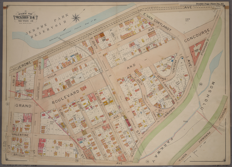 |
| Double Page Plate No. 35, Part of Ward 24, Section 12. [Bounded by Jerome Avenue, Mosholu Parkway North, Briggs Avenue a... (1901) |
http://
Mill Brook is long gone. At a point lost to historical memory, its full length was diverted into underground sewers. The motivation for this radical reengineering of the landscape is unclear; perhaps washing horse manure into an open stream created foul odors better diverted to the sewers. Whatever improvement was intended and perhaps achieved has now outlived its usefulness.
The stream feeds a combined sewer overflow, which results in raw sewage pouring into the waterways during heavy rains. Meanwhile, the topography on the parkway still drains toward the center. The water wants to carve out a stream bed. The result is muddy erosion in the lawns that dries into dustbowls.
 |
| Rain water drains to the center of the parkway, where it erodes the lawn in its attempt to restore its stream bed |
"At comparatively small expense, the natural brook which Mosholu Parkway already possesses can be enlarged, increased in volume by the aid of an artesian well, carried quite through the centre of the tract, and there is a sufficient descent to the grade to allow of the construction of dams enlosing lakelets, the overflow of which might be made to form miniature cascades, spanned by rustic bridges. Such ornamental attractions are possible in the plan of this broad parkway, which possesses natural conditions that permit of a wide scope for the invention and fancy of the landscape architect."
The New Parks Beyond the Harlem, 1887
 |
| As an example of the potential of daylighting Mill Brook on Mosholu Parkway, the gully could include a waterfall similar to this one in Prospect Park |
Sunday, November 24, 2013
Nobody to Play With
Parks in suburbs and small towns, particularly the playgrounds, have often been among the most disappointing places I have visited. On several occasions, I have had the unsatisfactory experience of taking my nephew or my son to a desolate set of play equipment. More often than not, these playgrounds have been wonderfully designed and well funded, perfectly graced with attractive, colorful structures that would challenge the skills of any playful child. The problem is the lack of children at play. Not even the most amazing play equipment is the match for other running children.
Sunday, November 10, 2013
Should urban planners care about dogs?

Fundamental to urban life is the ability for many people to live together in close proximity. Minimizing the nuisances that residents cause their neighbors is one of the most constant sources of friction and frustration. How dogs fit into this delicate balance is an interesting question. My contention is that despite a few challenges, dogs help draw together communities. We need to start considering the living conditions and infrastructure for dogs more fully and deliberately in urban planning.
First, we might consider how dogs could be nuisances to neighbors. After all, this has largely been the primary focus of governmental actions regarding pets for decades. So, how can the presence of dogs cause problems?
- Biting
- Spreading disease
- Barking or whining
- Pooping on the sidewalk
- Killing plants with excessive amounts of urine
Sunday, October 27, 2013
Civic Life for a Wino Park

There was a Halloween party for children at Whalen Park in the Norwood neighborhood in The Bronx on Saturday. More than a hundred kids attended with their parents. They played games. They made crafts. They danced to music played by a DJ. They sat and listened when the children's librarian from the Mosholu Branch Library next door came outside to read stories. Dozens of older adults gathered along the sidewalk right outside the park, leaning on the low fence to watch the spectacle inside and generally socializing with one another.

There has been an ongoing debate within the local neighborhoods about the future of Whalen Park. There are a few local individuals who share the view of senior officials at the Department of Parks and Recreation that the park should be converted to a playground and surrounded with a taller fence. The idea of converting the park is intended to force out the "undesirables." In New York City, adults are legally prohibited from entering a playground unless they are accompanying a child. This perspective seems to belong primarily to people who have only fleeting glimpses of the park, many of them local library patrons from an adjacent neighborhood.
Subscribe to:
Posts (Atom)