- See more at: http://www.bloggerhow.com/2012/07/implement-twitter-cards-blogger-blogspot.html/#sthash.DO2JBejM.dpuf
Showing posts with label crosswalks. Show all posts

Sunday, September 22, 2019

Barriers Against What?

There have been dire warnings recently that car manufacturers might try to exert their influence to take over city streets at the expense of pedestrians (again). A recent flare up followed the suggestion that some executives were considering the installation of gates at intersections to keep pedestrians from crossing against the light and interfering with autonomous vehicles. The backlash from urbanists was immediate: We should not repeat the mistakes of the past when cars were first introduced into cities. People should not be penned in on the sidewalks like cattle. Etc.

A couple of examples:

Caution is warranted, of course. The ability of autonomous cars to successfully navigate dense pedestrian areas is dubious, and some of the materials released by the auto industry have been outright frightening (see below). I agree with the need to be vigilant about the policies that may redesign our cities very quickly, setting new patterns that may hold for generations to come. In this case, though, it seems like a knee jerk response of the "if it's good for cars, it must be bad for pedestrians" variety. The idea surfaced, after all, as a solution to the potential problem of pedestrians interfering with the automated vehicles, which might become paralyzed if people deliberately walk in front of them, knowing that safety procedures designed to avoid injuring people will make them stop.


Nonetheless, I am fairly optimistic that automated vehicles can be leveraged to transform the places we live for the better, and I see crossing gates as an acceptable tradeoff. Likely enough, they could become a welcome addition to our streetscape.

Monday, January 1, 2018

Under the Roadway - Inspiration from Bethesda Terrace

It seems to be an article of faith among many contemporary planners that grade separation is an
ti-pedestrian and inherently anti-urban. In practice, this has been the case all too often; pedestrians have been forced to use uncomfortable overpasses and underpasses, diverted from a direct route to a grossly inferior detour. It is indeed a miserable experience when you're forced to climb steep stairs to walk across a narrow concrete pad over noisy traffic with a sharp wind cutting through the chain link fence, or to pass through a claustrophobic, musty, tunnel adorned solely by the exposed electrical conduit for the dim lights. Yet when we accept these bad places as our model for grade separation, we forget the concept's original vision and early success. This troubles me again each time I visit Central Park.


The ideas and work of Frederick Law Olmsted set much of the foundation for urban planning. His transverse roads in Central Park continue to successfully overlay a rustic park environment on a busy street grid. They make it possible for an expansive urban park to coexist with the city's street system. This is the baby we should not throw out with the bathwater.

And then there's Bethesda Terrace, the architectural showpiece of the park. It is an amazing progression of space, a place that is experienced by movement through a sequence of spaces. Grade separation here is not some mere functional layout. It is not just a safety feature. The experience of descending, the transition through a dark, constrained space that frames the view of the Angel of the Waters, and the reemergence into the open, sunny space is the design.

Tuesday, January 19, 2016

Is There a "One-Way Epidemic"?

Recently, City Limits ran an op-ed by architect John Massengale about the need for safer street design. Under the photo at the top, the caption read: "First Avenue in Manhattan. Avenues used to run two-way, which is safer for pedestrians, but were mostly made one-way, to make life easier for drivers." This argument was elaborated in detail in the text. This week, Cap'n Transit followed up on his blog, extending the campaign against one-way streets.

These are familiar arguments. After beginning a discussion a while ago about one-way streets, it was suggested that I refer to "The One-Way Epidemic" section in Walkable City, which makes these same claims. These pieces all serve as good examples for discussion purposes. I wholeheartedly agree with the need to redesign New York City's streets to be safer for pedestrians, and I share the majority of the views of these safe-street advocates. I find some areas of common ground regarding one-way streets, as well, but it is useful to draw out the key differences as well as the overlap to illustrate why the rhetoric against one-way streets is overblown and counterproductive.

Let's start with the term "epidemic" used in Walkable City. This is rhetoric that invokes fear. The book explicitly compares the creation of one-way streets with an outbreak of influenza that killed 20 million people in 1918-1919. The not-so-subtle claim is that one-way streets are an imminent threat to your life. Avoid them like the plague!

Saturday, July 26, 2014

Where Is the Plaza at Bay Plaza?

My family ends up out at the Bay Plaza shopping center in Co-Op City on a somewhat regular basis. Cinemas are becoming few and far between in The Bronx, and the AMC at Bay Plaza is one of our best options for a date at the movies. Despite all the drawbacks of the sprawling strip mall environment, it also remains one of our more convenient shopping alternatives for some needs. Like many others who frequent Bay Plaza, we get there by bus.


Unfortunately, the good money spent on bad design in Bay Plaza does not create a positive sense of place. It just makes transit passengers and the pedestrians from Co-op City feel second class. It makes the place less attractive and functionally inferior for shoppers who arrive by car as well.

There is no coherent network for internal pedestrian circulation.  Everything has been designed to move cars in and out of the parking lots, resulting in sidewalks that are narrow and often disconnected, as well as poorly designed crosswalks.  The transit stops have been dropped in as an afterthought, and are further challenged by their location on private property. Even for those who drive, getting between stores, restaurants, and entertainment is not particularly pleasant. Bay Plaza has put some attention into its landscape architecture in recent years (although there is room for great improvement for stormwater management with the endless acres of pavement!), but what it actually needs is an urban designer.

Nice landscaping.
Where's the sidewalk?

Wednesday, July 16, 2014

A Simple Dirt Path

This is a well-worn path on Needham Avenue where the sidewalk is missing. 

Needham Avenue is an underdeveloped street; it hasn't been built to its full mapped width, and the sidewalks have not been built. The rocks and trees offer a more scenic quality where there would normally be paved spaces. The narrower street offers shorter crossing distances, and those same rocks and trees act to calm traffic. 

Of course, this path subjects people to an uneven surface. This is of little consequence for most pedestrians on a typical day, and the mud when it rains isn't even that large an issue. Snow is substantially worse. For people with disabilities, it poses a larger problem still, which could significantly limit their mobility.


This street functions well with its narrow width. It would be amazing to see it simply improved with adequate sidewalks while preserving the trees and rocks. To really make the most, just add a couple of nice little rain gardens or bioswales.


View Larger Map


Friday, July 4, 2014

Conflicted Crosswalks: Hudson St and Christopher Columbus Dr

The intersection of Hudson Street and Christopher Columbus Drive in Jersey City has real potential to someday become a great public space at a lively, multimodal intersection. For now, it is a fragmented set of residual spaces with a traffic design that is inconvenient and uncomfortable for pedestrians and bus passengers. This is a case where excess concern about pedestrian-vehicle conflicts, combined with decisions to prioritize motor vehicles and a failure to realize that vehicular volumes never materialized, has resulted in a compromised pedestrian network that simply does not work properly. Let's look at how we can put it on a path toward realizing its potential.


This irregular intersection has only modest conflicts between pedestrians and vehicles. That is largely because the vehicular volumes are really quite light. Nevertheless, at this set of intersecting roadways, pedestrians are instructed to follow an extraordinary detour across several different crossings to avoid the potential conflicts with turning vehicles. To further the inconvenience, one of the crosswalks on that detour route has an unusually short pedestrian signal time.

This poor treatment of all the pedestrians who walk through the area is unnecessary, and it sets the wrong priorities by favoring motor vehicles. The whole confluence of intersecting streets should be reevaluated, and in the process it should be possible to create a whole new public space.

The crazy detour really is unnecessary. The conflict this whole situation was designed to avoid is so minor, it really seems unusual that the crossing was prohibited at all. Typical intersections throughout Jersey City and just about everywhere else have worse turning conflicts than this. With a close review of the signage that has been installed, the motivation can be discerned, but the aspect of the design that raised the concern is not only unnecessary, it creates a risk of vehicular collisions.

The pedestrian crossing is prohibited at this location because southbound Hudson Street has two right turn lanes.

The vehicles turning from the second lane would pose a real threat to pedestrians crossing the street, so in an attempt to maintain safe conditions for the pedestrians, the engineers attempted to remove them from the mix.

Despite the efforts of the engineers, the pedestrians who frequent this location exert their independence and continue to cross illicitly. By and large, they have little difficulty. Nevertheless, the apparent conflicts should be resolved, and can be resolved in a way that is much more satisfactory.

Sunday, June 29, 2014

The Wilderness

New York City Nature Preserves


By the time we can speak of preserving and protecting wilderness, it has already lost much of its meaning: for example, the Biblical meaning of awe and threat and the sense of sublimity far greater than the world of man and unencompassable by him.
"Wilderness" is now a symbol of the orderly process of nature.  As a state of the mind, true wilderness exists only in the great sprawling cities.
- Yi-Fu Tuan, Topophilia 


Tuesday, June 10, 2014

Growing Public Space from Grove Street

There is some exciting news that Jersey City may extend the public space from the plaza at the Grove Street PATH station further up Newark Avenue.


The plaza at the Grove Street PATH station


The existing plaza has already closed the easternmost block of Newark Avenue to traffic. Closing another block to traffic could make Newark Avenue part of an emerging trend of converting historical main roads into pedestrian space. The new plazas in Times Square are the prime example. Dating back to pre-colonial times, the trail that became Broadway was the main route up the island of Manhattan and beyond. Over time, its importance as the main traveled way waned as other routes were designed and constructed to standards more specifically meant to move vehicles, while local activities continued to crowd onto Broadway. Today, at Times Square, Broadway has been interrupted as a traveled way entirely. The social activities have asserted themselves as a place and the land has been converted into public plazas.

Streets experience a continual conflict between going and staying. Strips of land are transformed into active ways through the practice of travel, but the travel activities must push aside other uses that might utilize the space. Roads have been characterized as non-places. This is appropriate in a way, since places are spaces where people stay. The road or street is the space people use to leave.

Sunday, June 1, 2014

Legally Blocking the Crosswalk?


The first question on anybody's mind is surely: What kind of jerk parks in the crosswalk?


The more important question is: Why would New York City, a place that relies so heavily on walking, enact regulations to make it legal?

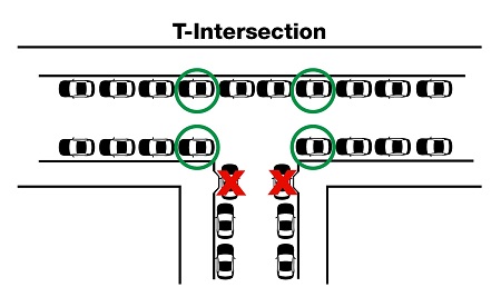
In 2008, the New York City Department of Transportation (NYC DOT) quietly changed the parking rules to allow drivers to block unmarked crosswalks at T-intersections.

According to the New York City Department of Transportation
it is legal to park in the locations indicated with red circles.
Source: NYC DOT

Saturday, May 24, 2014

Conflicted Crosswalks: The Grand Concourse


You know it's bad when they put up the You're-gonna-die signage.


Getting across the Grand Concourse in one piece can be a challenge. The combination of long crossing distances and multiple conflicting movements from split side streets gives turning drivers seemingly endless possibilities to take a shot at you. And virtually every car on the cross streets are turning (through traffic bypasses the intersection by passing below the Grand Concourse).

Even with the challenging physical conditions presented by these intersections, there seem to be some easy improvements that might help pedestrians. High-visibility crosswalk markings are one example. There may be opportunities to make the yield signage more visible to motorists and locate it to better influence behavior before drivers make their decisions. The signal timing should also be reviewed to give pedestrians a head start.

Sunday, April 13, 2014

Old Institutions Need New Vision

This is not the type of intersection you want to cross with your children to go to the zoo:

It's not really the type of intersection you would ever want to cross to go anywhere. It's too wide, and has too many fast-moving cars making turns through the crosswalk while you're trying to get across.

Of course, there is nothing much unusual about this type of intersection. This has been a fairly standard approach to designing major streets all across the continent for decades.

What is remarkable is that much of the section of Fordham Road/Pelham Parkway that begins at this intersection was just recently reconstructed here in New York City, where the Department of Transportation has earned an international reputation for its innovative street designs. Sometimes the old highway mentality can be persistent, even in transportation departments that are at the forefront of change.

This vast and expensive reconstruction also exposes the outdated views of the major cultural institutions in The Bronx. The project was initiated and moved to the top of the City's priority list by the "Four Bronx Institutions." With their drive and input, the project completely rebuilt the frontage between the Bronx Zoo and the New York Botanical Garden, two of the four member institutions, so it really demonstrates the vision they have for their patrons and employees, the surrounding neighborhoods, and each other. That vision belongs in the dustbin of the past, but I am afraid we will be forced to live with this new construction  long into the future.

Saturday, April 5, 2014

Connecting Neighborhoods Across Mosholu Parkway

Mosholu Parkway is a great shared civic space between the Bedford Park and Norwood neighborhoods. One of the aspects that first impressed me about this area was the groups of older men who walk together and talk on the parkway. Yet while the parkway is a place where the community comes together, it also acts as an inconvenience for movement between the neighborhoods.


There are some long stretches on Mosholu Parkway between intersections, which are the only locations where pedestrians may legally cross the roadways. At several of the intersections, pedestrians are confronted with regulatory signs prohibiting them from crossing at certain corners, imposing yet more limitations on their ability to get around easily.

These locations where pedestrians are prohibited from crossing should be changed. Prioritizing the turning movements of drivers cutting through the community over the residents walking between neighborhoods is the wrong choice. At these locations, the prohibitions appear to do very little to benefit the drivers anyway. The volumes of turning vehicles and pedestrians appear modest enough that allowing pedestrians to go where they want should not create any real problems with turning delays.

Monday, March 17, 2014

Conflicted Crosswalks: Washington St. and Columbus Dr. in Jersey City

This is the second in a series of posts about crosswalks with conflicts that threaten pedestrians. These are intersections located in neighborhoods that are not living up to their full potential, due in large part to traffic that is hostile to walking. As they exist today, these street corners are not neighborhood places; they are merely the residual space where flows of vehicular traffic collide. Each intersection has its own unique problems, but looking at several cases will help to identify some commonalities. This time we look at Washington Street and Columbus Drive in Jersey City.

One of my colleagues was complaining to me about drivers failing to yield to pedestrians in a crosswalk near our office. He was particularly concerned that the traffic controls were giving left-turning drivers a left arrow at the same time pedestrians had a walk signal. This clearly creates a conflict (which concerns me even more for nighttime operations, given reduced visibility and the likelihood of impaired pedestrians leaving the bar on the corner crossing the street en route to the light-rail station or a bus stop).


My colleague and I both had an initial thought that this signal sequence would be prohibited by engineering standards. Yet when my colleague looked it up in the Manual on Uniform Traffic Control Devices (MUTCD), it appears it is actually allowed:


Section 4D.04 Meaning of Vehicular Signal Indications


...1. Vehicular traffic facing a GREEN ARROW signal indication, displayed alone or in combination with another signal indication, is permitted to cautiously enter the intersection only to make the movement indicated by such arrow, or such other movement as is permitted by other signal indications displayed at the same time.Such vehicular traffic, including vehicles turning right or left or making a U-turn movement, shall yield the right-of-way to:
  1. Pedestrians lawfully within an associated crosswalk, and
  1. Other vehicles lawfully within the intersection...
...3. Pedestrians facing a GREEN ARROW signal indication, unless otherwise directed by a pedestrian signal indication or other traffic control device, shall not cross the roadway.

Monday, February 17, 2014

Dashing through the Snow

Dashing through the snow, climbing icy hills, across the street we go, hoping we don't get killed...

This snow mound in the middle of the crosswalk creates a hazardous condition. It was downright terrifying with our stroller this afternoon!


The thing is, at this specific location, the problem is entirely avoidable. The pedestrian refuge area consists solely of markings; there is no raised concrete island (nor ADA tactile warning strips). The snow plow that cleared the vehicular lanes could have made equally quick work of the crosswalk and pedestrian refuge. The only minor challenge of any type is avoiding the small concrete base for the pedestrian signal light.

Beyond the matter of getting the snow plows to clear out this specific mess, it raises a possibility for the design of pedestrian refuges. Recently, designs have evolved into a cut-through to accommodate ADA, rather than a ramp-up/ramp-down combination. Looking at it during the winter is enough to wonder if it would be ideal to align the accessible pedestrian ramps and ensure they are suitably wide that a small plow could clear the whole thing. The largest challenge that presents itself is the tactile warning plates they way they are currently being installed at many temporary plaza locations. To avoid being stripped off by a plow, it would be critical to ensure they were inset instead of simply overlaid on the pavement.

Saturday, February 8, 2014

Conflicted Crosswalks: Gun Hill Road and Webster Avenue

This is the first of a series of posts about crosswalks with conflicts that threaten pedestrians. These are intersections located in neighborhoods that are not living up to their full potential, due in large part to traffic that is hostile to walking. As they exist today, these street corners are not neighborhood places; they are merely the residual space where flows of vehicular traffic collide. Each intersection has its own unique problems, but looking at several cases will help to identify some commonalities. The first intersection we will review is Gun Hill Road and Webster Avenue in The Bronx.

This is an intersection that periodically injures pedestrians, sometimes fatally. Taken as an absolute number, the accidents are on the high side but may not stand out as a priority. However, after considering that the total pedestrian activity is quite low, it becomes apparent that the actual crash rate is particularly high and clearly indicates a problem. (A deeper review would indicate that the unsafe intersection is a major factor in suppressing pedestrian volumes, as people avoid the intersection and trips between the neighborhoods altogether for fear of being hit by a car!) Pedestrians crossing Webster Avenue on either the north or the south side encounters real problems with left-turning vehicles.


Tuesday, February 4, 2014

Taming Traffic on Mosholu Parkway

Mosholu Parkway is the edge between Norwood and Bedford Park. It is a wonderful greenspace, and it's socially active. Nevertheless, the traffic divides the neighborhoods and is always a source of concern for the residents who cross it. The parkway could become a safer and more enjoyable unifying feature for our neighborhoods if we just tamed the traffic. We can do this by reducing the speed limit and by redesigning the roadway to calm traffic while improving the landscape.

Let's start with the speed limit. While the citywide speed limit in New York City is 30 mph, on Mosholu Parkway it has been increased to 35 mph. I know 5 mph may not sound like much, it makes a huge difference. At faster speeds, it is more likely a driver will hit something, or somebody. That is because their ability to perceive pedestrians is lower, they have less control over the vehicle, and they need more distance to stop. Going 35 instead of 30 mph, a car can take an extra 50 feet to come to a stop.


View Larger Map

The risk of pedestrian injuries and death increases rapidly as speeds exceed 20 mph (that is why advocates are currently campaigning to reduce the citywide limit). A pedestrian hit at 35 mph is about two times as likely to die as a person struck by a vehicle going 30 mph.

Sunday, January 5, 2014

"Sneckdowns"

@StreetsblogNYC pic.twitter.com/tpVZjqTk28
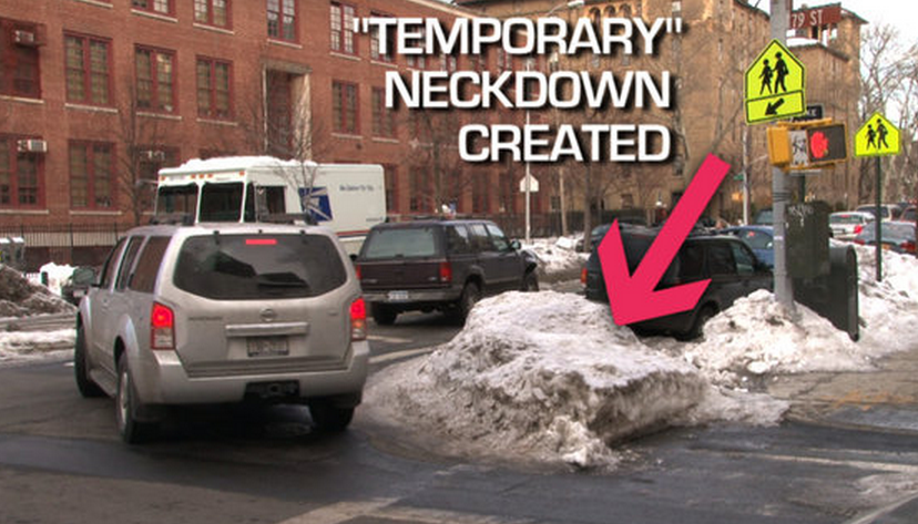
The #sneckdown tag has been trending on Twitter. The term is a clever combination of the words "snow" and "neckdown." The tag is used with photos of snow at intersections where it has not been cleared by vehicles, leaving areas that closely resemble neckdowns (see p. 74 of NYC DOT's Street Design Manual). As it is currently trending, these generally have an implicit or explicit claim of demonstrating that space is wasted by vehicles and could be used instead for traffic calming and pedestrian space.

I initially saw some discussions about "sneckdowns" last winter, with useful observations about how the snow piles were acting as temporary traffic calming. This winter, I noticed #sneckdown making the rounds at the first snowfall here in New York. Rather than discussing the temporary effects or snow plowing practices, the focus seemed to have shifted to claims that the areas that had not been cleared by vehicles should be converted into permanent neckdowns.

I found the original observations and discussions about snow plowing very useful. The observations about roadway space that wasn't actively used after the snowfall also initially struck me as something that might inspire a closer look at specific intersections. However, as the popularity of the #sneckdown tag grows and more people jump on the bandwagon with their own photos, I am becoming increasingly uncomfortable.

Saturday, December 28, 2013

Paint the Town


Transportation engineers have long been painters, although the markings they have applied in white and yellow are not something anyone has ever recognized as artwork. Of course, they never intended for their functional markings to be a visual art (although their engineering work can be as much art as science at times). I find it interesting to note the pallet they use has been expanding in recent years, and our cities are gaining a little more colorful accent as a result. In some cases, transportation agencies are even using paint to create public art in places that have traditionally been mundane or outright unsightly.

Here's a quick rundown of the color pallet used for functional markings, a note about incorporating art to mitigate the unattractive spaces sometimes created by transportation, and some discussion of the limitations of paint.