- See more at: http://www.bloggerhow.com/2012/07/implement-twitter-cards-blogger-blogspot.html/#sthash.DO2JBejM.dpuf
Showing posts with label traffic calming. Show all posts

Monday, February 9, 2015

Stolen Space and Leftover Space

The 52nd Precinct steals space from the community every single day. The inconvenience and the perception that the police lack respect for the law create an ongoing source of tension with the community the NYPD is supposed to serve. A review of the conditions surrounding the precinct demonstrates that parking could, in fact, be managed satisfactorily with a little professional attention and a basic level of discipline. The parking is, in fact, illegal, and the NYPD has an obligation to restore order both to maintain its own integrity and to relieve the burden on the community that hosts the station house.

Unlike many station houses in New York City, the 52nd Precinct has its own off-street parking lot. This is not a cheap piece of infrastructure, either, since it is largely on a deck over the MetroNorth Railroad. Additional exclusive parking has been created with parking regulations that dedicate the curb lane on the east side of Webster Avenue to the precinct. Yet this is not enough to keep the East Coast Greenway clear of parked cars.

These cars are parked on a shared-use path
that is part of the East Coast Greenway
Over the years, every commanding officer and the Community Relations officers have consistently said they plan to repave and stripe the parking lot to increase the amount of parking by reducing the space generally lost to an inefficient ad hoc layout, as well as drivers supposedly trying to avoid mud puddles. Yet after years, there has been no change. The only maintenance ever performed on the lot is to periodically fix the fence posts when drivers have damaged it again (a sign that is not particularly encouraging about the driving abilities of the officers who cruise the neighborhood all day long).

Wednesday, November 12, 2014

Filling the Void, Maintaining Sight Lines

When cars park too close to the corner, drivers and pedestrians often cannot see each other well enough to make safe decisions. To correct the problem, parking is frequently prohibited near intersections to improve sight lines, a practice sometimes referred to as "daylighting." Nevertheless, regulations cannot actually prevent the hazardous conditions from continuing. The public and even some enforcement agencies seem to have a low level of awareness or appreciation for the need to keep these locations clear, and the residual nature of these spaces continues to be problematic.


In an effort to improve the situation, enhanced markings are often used to reinforce the regulatory signage. Even with this effort to emphasize the regulations and create some illusion of occupancy, the space continues to feel unused. In an active urban environment, a space marked off for the sole purpose of a sight line really is, in practice, underutilized. The demand to make more intense use of it is probably inevitable.

The solution to these residual spaces is to provide them with uses that do not compromise the sight lines. To be effective and persuasive enough to continue installing them elsewhere, treatments must embrace uses that are appealing to the community.

The classic response is to install a curb extension, sometimes called a "neckdown." These rely on the curb as a physical barrier that effectively discourages parking. They also provide benefits for traffic calming and shortening crossing distances for pedestrians. A curb extension is an expansion of the sidewalk, creating more usable space for pedestrians, although they may recognize relatively little value in the extra panels of concrete. This solution is often complicated, though, by mundane engineering details like drainage or even traffic signal location. Capital costs can discourage or delay construction.

Saturday, August 16, 2014

Old Town in Salinas

A few months ago, I passed through Salinas, California for a funeral. I wish the circumstances had been better, and that I could have spent a little more time and had an opportunity to speak with some of the local planners. The relationships between the spaces along the Main Street corridor in Old Town seemed quite interesting.

The Main Street commercial core in Old Town is a compact area. This is due in part to its conversion into a sort of enclave. It encompasses a relatively short distance of Main Street that is effectively demarcated from the rest of its length. The busier arterial streets that flank the Main Street core also create some separation from the surrounding area. It is interesting to note that this length of Main Street is generally consistent with the "400 meter rule." The section from San Luis Street to its termination at the Steinbeck Center is a little under 500 meters. It is also significant that the Steinbeck Center terminates the vista and encloses this section of street more like an outdoor room.

While many planners who talk about walkable downtowns are quick to promote two-way streets as a sort of pedestrian panacea, it is interesting to note that the pedestrian-friendly area of Old Town is along a one-way section of Main Street. The use of angled parking effectively calms the traffic, as do the mid-block sidewalk extensions with pedestrian crossings. The traffic calming treatments could be applied to either one-way or two-way streets, although it may be possible to introduce angled parking on a second side of the street on some one-way streets that would not have sufficient width under a two-way configuration. A one-way configuration also has the inherent advantage of limiting the demands on pedestrians to try simultaneously gauging traffic coming at them from two different directions at uncontrolled mid-block crossings.


View Larger Map
The angled parking and the mid-block sidewalk extensions calm traffic

The mid-block crossings form a pedestrian axis that is more than just an extra place to cross the street between intersections. They align with pedestrian passageways through the block to parking areas on the other streets. In some cases, these passages provide additional store frontage or space for outdoor restaurant seating. It was not clear on my quick visit if the outdoor restaurant seating had failed, or if it was a seasonal use that hadn't started yet for the warmer months when I was there.

Wednesday, July 16, 2014

A Simple Dirt Path

This is a well-worn path on Needham Avenue where the sidewalk is missing. 

Needham Avenue is an underdeveloped street; it hasn't been built to its full mapped width, and the sidewalks have not been built. The rocks and trees offer a more scenic quality where there would normally be paved spaces. The narrower street offers shorter crossing distances, and those same rocks and trees act to calm traffic. 

Of course, this path subjects people to an uneven surface. This is of little consequence for most pedestrians on a typical day, and the mud when it rains isn't even that large an issue. Snow is substantially worse. For people with disabilities, it poses a larger problem still, which could significantly limit their mobility.


This street functions well with its narrow width. It would be amazing to see it simply improved with adequate sidewalks while preserving the trees and rocks. To really make the most, just add a couple of nice little rain gardens or bioswales.


View Larger Map


Saturday, May 24, 2014

Conflicted Crosswalks: The Grand Concourse


You know it's bad when they put up the You're-gonna-die signage.


Getting across the Grand Concourse in one piece can be a challenge. The combination of long crossing distances and multiple conflicting movements from split side streets gives turning drivers seemingly endless possibilities to take a shot at you. And virtually every car on the cross streets are turning (through traffic bypasses the intersection by passing below the Grand Concourse).

Even with the challenging physical conditions presented by these intersections, there seem to be some easy improvements that might help pedestrians. High-visibility crosswalk markings are one example. There may be opportunities to make the yield signage more visible to motorists and locate it to better influence behavior before drivers make their decisions. The signal timing should also be reviewed to give pedestrians a head start.

Tuesday, February 4, 2014

Taming Traffic on Mosholu Parkway

Mosholu Parkway is the edge between Norwood and Bedford Park. It is a wonderful greenspace, and it's socially active. Nevertheless, the traffic divides the neighborhoods and is always a source of concern for the residents who cross it. The parkway could become a safer and more enjoyable unifying feature for our neighborhoods if we just tamed the traffic. We can do this by reducing the speed limit and by redesigning the roadway to calm traffic while improving the landscape.

Let's start with the speed limit. While the citywide speed limit in New York City is 30 mph, on Mosholu Parkway it has been increased to 35 mph. I know 5 mph may not sound like much, it makes a huge difference. At faster speeds, it is more likely a driver will hit something, or somebody. That is because their ability to perceive pedestrians is lower, they have less control over the vehicle, and they need more distance to stop. Going 35 instead of 30 mph, a car can take an extra 50 feet to come to a stop.


View Larger Map

The risk of pedestrian injuries and death increases rapidly as speeds exceed 20 mph (that is why advocates are currently campaigning to reduce the citywide limit). A pedestrian hit at 35 mph is about two times as likely to die as a person struck by a vehicle going 30 mph.

Sunday, January 5, 2014

"Sneckdowns"

@StreetsblogNYC pic.twitter.com/tpVZjqTk28
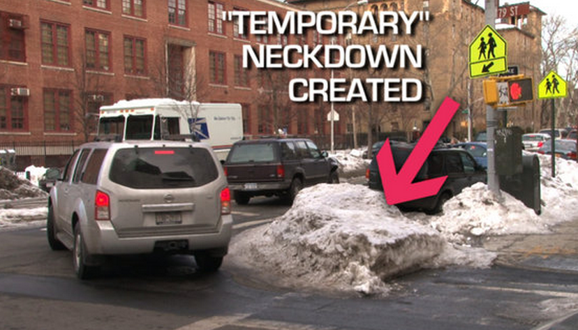
The #sneckdown tag has been trending on Twitter. The term is a clever combination of the words "snow" and "neckdown." The tag is used with photos of snow at intersections where it has not been cleared by vehicles, leaving areas that closely resemble neckdowns (see p. 74 of NYC DOT's Street Design Manual). As it is currently trending, these generally have an implicit or explicit claim of demonstrating that space is wasted by vehicles and could be used instead for traffic calming and pedestrian space.

I initially saw some discussions about "sneckdowns" last winter, with useful observations about how the snow piles were acting as temporary traffic calming. This winter, I noticed #sneckdown making the rounds at the first snowfall here in New York. Rather than discussing the temporary effects or snow plowing practices, the focus seemed to have shifted to claims that the areas that had not been cleared by vehicles should be converted into permanent neckdowns.

I found the original observations and discussions about snow plowing very useful. The observations about roadway space that wasn't actively used after the snowfall also initially struck me as something that might inspire a closer look at specific intersections. However, as the popularity of the #sneckdown tag grows and more people jump on the bandwagon with their own photos, I am becoming increasingly uncomfortable.